Revisiting the gorgeous Mt Princess
Some hikes are a literal walk in the park, while others test your limits in good or bad ways with type two fun. Sharon Davis tells us about having her sense of humour tested on a return trip to a remote alpine tarn on Mt Princess.
Some tramps are like childbirth. Painful, yet beautiful and exciting all at once. Over time, you forget or deliberately blank out the desperately hard parts and return now and then to gaze lovingly at the beautiful photos. Then a year or two later, you catch yourself thinking: We should do that again.
That’s exactly what happened after my first trip to Princess Bath. I'd almost forgotten the hard slog and wanted to return.
After our first trip, I vowed to return for an overnight trip. I wanted to relax in the alpine splendour, watch the stars twinkle while lying on my back, and catch the early glints of sunrise – but none of my hiking buddies were keen to carry overnight gear and camp out.
So there I was, driving along Tophouse Road and coaxing my X-Trail up Maling Pass to revisit Princess Bath with Mirjam, who was innocently and excitedly embarking on her maiden voyage to the lofty basin.
I honoured my promise not to attempt to drive to Hanmer Springs, walk in, walk out, and drive home again in one (very long) day. But, I agreed to do the walk in a day - while based at a holiday cottage in Hanmer.
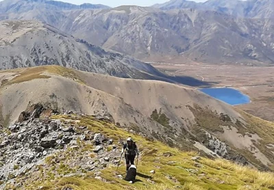
There aren't any marked tracks or trials to the large tarn below Mt Princess, known as Princess Bath, but there are several routes to get there.
The 360m climb from Maling Pass to Point 1572 seemed easier than last time - if only because I'd done it before and knew where I was going.
After Pt 1572, the route drops into a saddle. On the first trip, we turned right at the saddle and picked the path of least resistance over a ridge, down the other side and then up above the lip of the tarn and back down to the water. With the benefit of hindsight, that is the easier option by far.
This time, we picked the traditional route over scree onto a rocky ridge.

We scrambled through scree and climbed the gnarly ridge, arriving at a small tarn.
The day was warming up, and it was a perfect stop for border collies Shanti and Scruff to enjoy a swim while the humans had a rest and refreshment break.
I was in good spirits and wondering if we would have time to look at the route up Mt Princess, which sits ruggedly aloof some 300m above the bath.
But as we got closer to midday, while picking our way laboriously through boulder fields, I realised that bagging a 2100-plus-metre peak wasn't going to happen for this princess on the mountain today.
I wilt in the heat - and it was baking hot. Making it to the bath and back in one piece would be hard enough when throwing in the towel and having a right royal tantrum was already on my mind.
We picked a line hoping to traverse and avoid climbing above 1900m, but the easiest travel was on the stony ridge top, so up we went.
It took at least three hot hours to cover 3km (as the crow flies) until the rough undulations of the ridge eased downward toward the bath.
Mirjam was well pleased, but I knew it was another 30 minutes of knee-jarring boulder-strewn descent to reach the water.
The dogs and Mirjam enjoyed a swim in the bath while I watched, feeling miserable as I tried to convince an uneasy stomach that food was a good idea. Hiking in the heat does not agree with me.
It would have been perfect if we were camping for the night. But we weren't - and I was dreading doing it all again in reverse.
Of course, I had to get over myself and start walking.
On the spur of the moment, I thought of a way to avoid a climb back up the looming ridge. I'd studied a Canterbury Mountain Club trip report of a route down the true right of the bath and suggested we give it a go - and off we went.
Between my vague idea of the route and the dogs' keen sense of direction, we picked our way carefully down the near-vertical cliff and arrived in the valley scree about 400m below about an hour later.
I'd been worried that we could end up stuck above a cliff so I was feeling very pleased with myself (and the dogs) at that point.
The trip report for the rest said: Follow the valley out to the Maling Pass road.
Easy as, right?
The scree-filled valley offered reasonable travel and my spirits soared. But the easy travel soon gave way to gorse and chest-high scrub.
Then we were pushing through head-high bush while falling into hidden creeks and clambering out of secreted (stinky) swamps in strictly type two fun territory.
Just follow the hot, breathless valley my ar*e!
Much swearing and perspiring later, we crossed Princess Stream yet again and huddled under some trees to rest and drain the last of our water from dog bowls and coffee from flasks.
Even Scruff, the Every-Ready collie, lay down to rest without a whimper of what's next, are we going yet?
Four hours and 4km from Princess Bath we arrived back at the car.
I was having flashbacks from the first trip. One ridge descent away from the car, we'd stopped paying attention to the route and headed down the wrong ridge. That added 30 minutes of scrub bashing and a lot of expletives to the day.
But this route was way worse. Long before the car, I'd vowed never, ever, ever to attempt the valley route again. Bush bashing on tired legs with a long-lost sense of humour was not something I wanted to repeat. Ever.
I might have also stated that I would never return - and I'm pretty sure I promised never to return in the heat of January or February. But it's been a couple of years and I'm looking longingly at those photos again... and thinking about that coveted overnighter, a possible side trip to the summit of Mt Princess, and hiking plans for the New Year break.
Know before you go
This trip is for people with backcountry experience, who are comfortable with navigation and route finding in alpine terrain. Take a tent or emergency shelter and a personal locator beacon (PLB) or similar device.
Where: St James Conservation Area (Jacks Pass access from Hanmer Springs)
Princess Bath: The bath is a large mountain lake at 1750m. It's nestled in a cirque below Mt Princess (2126m).
Getting there: Drive up Jacks Pass from Hanmer Springs. Turn left onto Tophouse Road and head toward Lake Tennyson. Just before the lake, there is a 4WD track up to Maling Pass. In good road conditions, my AWD X-Trail has managed the track comfortably. Allow at least an hour for this drive. Check the Department of Conservation website for access to Maling Pass. The test run without a lock might have been successful, or you might need a code for the padlock on the gate as we have in the past.
The track: There are no official tracks, but there are three access route options. One is from Lake Tennyson over Mt McCabe or McCabe Saddle. The second is to follow Princess Stream up the valley - similar to the route we came down. The third (and easiest) is from Maling Pass.
Other options: For less challenging walking tracks in the St James Conservation Area, consider a walk to Cow Stream Hot Pools or Scotties Hut (access from Edwards Pass or the St James Homestead via Peters Pass) or a walk over Fowler Pass to Stanleyvale and Lake Guyon. Day walks up Mt Dunblane or Mt Isobel also offer spectacular views.
Dog access: Dogs are allowed in the St James Conservation Area east of the Waiau River. Check the Department of Conservation poison map before you go.
By Sharon Davis