Local gem set to reopen
I set off from the carpark, just a short drive from Staveley, following a mud-splattered Charles Ross who had been part of a working bee further along the South Face Track on Mt Somers.
It’s cool in the shade of beech and rata, but I warm up enough on the gentle incline to slip my jacket off.
Within a few minutes, I’m guided past a gate that shuts off access to the track – for now – to follow the sturdy shingle track to the falls.
The track is a labour of love over five or more years for the Mt Somers Walkways Society.
Members have worked tirelessly since the track closed because of the risk of rockfall.
The devastating earthquakes that rocked Canterbury in 2010 and 2011 set off a series of slips and rock falls that came down on the original track in the ensuing years.
DOC closed the original track in 2017 because of the risks from the unstable ground and a lack of funds to invest in a new track.
However, the walkways society was able to leverage its track record of helping on the Mt Somers track to convince DOC to let them build a new track on the opposite side of Bowyers Stream.
The society raised $560,000 to build the track, but estimate that volunteer hours and donated materials brought the total to about $800,000.
I zigged down the zig-zags, built to skirt a rockfall zone, while being regaled with track-building stories of near misses with rolled diggers, or barrowing in loads of shingle.
The most impressive was a story about the young “heavy lifting crew” who helped on the track. They loaded up with two 20kg bags of cement and a post each – and did that twice to save the cost of flying it in.
“That’s why the track is so well packed down,” quipped society president Charles Ross as I plodded the short uphill section accurately signposted as the Plod.
Fantails flitted by as I walked through the Clay Cutting and Grassy Slip, through Rocky Cutting to the most impressive feat of the track building effort – the bridges across Bowyers Stream.
The bridge spans were flown in by helicopter in January this year. Each span was placed on scaffolding and bolted in place before the scaffolding was removed.
I dallied here to use the bridge handrail as a makeshift tripod for a long exposure photo of the flowing water, then rushed along the meandering track to the second bridge – which appears to end in a boulder.
Spoiler: The track skirts to the side of the boulder and climbs a few steps before ending at a platform with a clear view of the multifaceted falls.
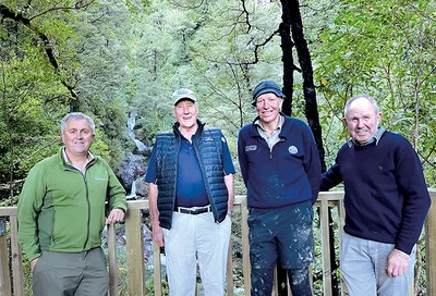
We caught up with local DOC operations manager Tony Preston at the viewing platform.
He was out inspecting the track and had nothing but praise.
DOC had walked away from the track to the falls because of the unstable environment, but the society “pulled it off in style”, he said.
The whole project was done by the walkways society.
“The only thing DOC did was get in the way with a bit of paperwork,” Preston said.
As a track builder for DOC in his earlier days, Preston said he was well aware of the size of the undertaking to build the track.
He said his eyes were as wide as saucers as he walked the track this past week.
“For a community group to pull off a project of this size is amazing. I can’t rave enough about it.”
Preston said the next hurdle for the track would be parking.
Once people returned for family walks to the falls the current parking space would not be large enough, he said.
The good news is that the walkways society is already starting to mull that particular problem over.
- By Sharon Davis
